
A property is generally considered walking distance to MRT in Singapore when it sits within 10 minutes, or roughly 800 meters, of a station entrance. Buyers and agents narrow that further to a practical sweet spot of a few hundred meters, commonly cited as around 400 to 500 meters, roughly 5 to 10 minutes on foot. The catch: that number only holds if the actual route is direct, sheltered, and free of the crossings and detours that turn a "close" address into a longer walk than the listing suggests.
TL;DR:
- Trusted tools like OneMap and Google Maps can help verify true walking distance and time, especially by cross-checking route differences exceeding a minute or two.
- Sheltered, continuous pathways significantly shorten perceived walking time, making route quality crucial for comfortable daily commutes.
- Property price premiums drop sharply as distance from MRT exceeds 200 meters, with a 15 to 22% premium within 200 meters falling to minimal premiums beyond 800 meters.
- Buyers should personally walk the route at different times, examine route features, and verify specific exit details rather than relying solely on marketing distance claims.
Table of Contents
- Walking Distance Benchmarks: A Quick Reference
- How to Measure the Real Walking Distance to MRT
- What Makes a Walk Feel Shorter or Longer Than It Is
- How MRT Proximity Shapes Property Prices in Singapore
- A Buyer's On-Site Checklist for Verifying MRT Distance
- How Aurea Documents Its Walking Routes to MRT
- Where to Verify Walking Distance Claims Yourself
- The Gap Between the 800-Meter Rule and What Actually Matters
- Sources
Walking Distance Benchmarks: A Quick Reference
Not all "near MRT" claims mean the same thing. Distance bands shift both daily convenience and how the market prices a unit, and the difference between one band and the next is often just a few minutes on foot.
- Under 200 meters — Station-linked or effectively on the doorstep. This is the rarest tier in Singapore and carries the strongest convenience and price premium, though it can also mean more foot traffic and noise near the entrance.
- 200 to 400 meters — The zone most agents call the "MRT premium" band. A 3 to 6 minute walk here is widely seen as the ideal balance: close enough to skip a bus, far enough to avoid station crowds spilling into the lobby.
- 400 to 600 meters — Comfortable for most commuters, but the experience depends heavily on route quality. A straight, sheltered path at 550 meters can feel shorter than a broken one at 350 meters.
- 600 to 800 meters — The outer edge of what most people call walking distance. Still workable, especially for younger commuters, but it starts to feel like a real walk rather than a quick hop.
- Over 800 meters — Generally falls outside the conventional definition. Expect a noticeably smaller price premium, and expect residents to lean on buses, bikes, or ride-hailing more often than their feet.
How to Measure the Real Walking Distance to MRT
Straight-line distance and walking-route distance are rarely the same number, and the gap is where marketing claims tend to stretch the truth. A unit that is "350 meters from Exit 3" on a straight ruler line might require a 550-meter detour around a canal, a highway, or a fenced compound. Researchers studying pedestrian access in Singapore built the concept of equivalent walking distance specifically to capture this gap, since crow-fly measurements consistently understate the real effort involved.
Here's how to check any property's actual walking time before you take an agent's word for it:
- Pull up OneMap and set walking directions from the exact unit block or entrance to the specific MRT exit you'd use, not just the station name.
- Cross-check the same route on Google Maps walking mode. If the two disagree by more than a minute or two, walk it yourself.
- Time an on-site walk at a normal pace, ideally during both a weekday morning and an evening, since crowd flow and traffic light timing change the real duration.
- Log every delay you hit along the way, including road crossings, lift waits at overhead bridges, and any detour around construction or private property.
Pro Tip: Screenshot both the OneMap and Google Maps routes with timestamps, and jot down your own timed walk on the same page. That record becomes useful leverage if you ever need to challenge a listing's "5 minutes to MRT" claim during negotiation.
What Makes a Walk Feel Shorter or Longer Than It Is
Two properties at the identical 450 meters from a station can feel completely different underfoot, and the difference usually comes down to a handful of physical factors that raw distance never captures.
- Barrier-free continuity matters most for anyone with mobility needs. SMRT documents standard accessibility features including tactile ground indicators, wider accessible fare gates, and lifts at every station, and it's worth confirming these are functioning, not just present.
- Sheltered, continuous walkways count for more in Singapore's climate than almost anywhere else. A route under a covered link bridge beats an unsheltered one of the same length whenever it rains, which in Singapore is often.
- Crossings, stairs, slopes, and surface quality all add friction. A single signalized crossing can add a minute or more depending on the light cycle, and a flight of stairs changes the calculus entirely for strollers, wheelchairs, or anyone hauling groceries.
- Age, mobility, and weather shift what counts as "comfortable." A 10-minute walk that's trivial for a fit commuter at 7 a.m. can feel much longer for an elderly resident at midday under direct sun.
Field surveys measuring these effects found an average walking distance of about 608 meters among Singapore commuters who walk to stations, with roughly 60% of MRT passengers choosing to walk rather than take a connecting bus. That figure reflects real routes with real obstacles, not the tidy straight lines drawn on marketing brochures. Resources like Haio cover inclusive access design in more depth for readers who want to understand barrier-free planning beyond the station gate.
How MRT Proximity Shapes Property Prices in Singapore
Distance from an MRT station is one of the most consistent price drivers in Singapore's condo market, and the relationship isn't linear. Market analysis of price premiums by distance band shows a steep drop-off the further a unit sits from the station:
- Under 200 meters: roughly a 15 to 22% premium over comparable units farther out
- 200 to 400 meters: roughly 10 to 18%
- 400 to 600 meters: roughly 6 to 12%
- 600 to 800 meters: roughly 3 to 7%
- Beyond 1.2 kilometers: minimal premium, sometimes none at all
That premium tends to stretch even further near an interchange station or a line with direct CBD access, since the same 100-meter difference in distance carries more weight when the station connects to multiple lines rather than sitting on a single spur. None of this happens in isolation, though. Floor level, unit aspect, remaining lease term, and the building's amenities all layer on top of distance, so two units at an identical 300 meters from the same station can still sell at meaningfully different prices.
A Buyer's On-Site Checklist for Verifying MRT Distance
Bring this with you on a viewing, because a floor plan and a listing sheet won't tell you what your actual commute feels like.
- Walk the route yourself at peak and off-peak hours, counting every road crossing and timing any lift wait if the route includes an overhead bridge.
- Check whether the sheltered path is continuous from the building entrance to the station, and identify an alternative route in case of rain or construction.
- Ask the agent or developer for the specific exit number, an official station map, and, where relevant, the maintenance record for any link bridge or underpass along the way.
- Watch for red flags: a circuitous route that doubles the straight-line distance, no sheltered link at all, or lifts with a history of outages. Each is a legitimate point to raise during price negotiation.
Pro Tip: If you have a stroller, a wheelchair, or simply want to stress-test the route, walk it with that equipment rather than imagining how it might go. A curb cut that looks fine on paper can be a real obstacle in practice.
How Aurea Documents Its Walking Routes to MRT
Aurea-sgcondo publishes route maps and exit references for the walk between its Beach Road units and nearby MRT stations, measuring actual walking-route distance rather than relying on a straight-line figure that ignores crossings and building layouts. The development highlights its link bridge to The Golden Mile and sheltered path connections specifically because continuity, not just proximity on a map, is what determines whether a walk feels quick or tedious. For buyers comparing claims across projects, that level of route-level detail is the standard worth expecting.
Where to Verify Walking Distance Claims Yourself
Use OneMap for the government's authoritative walking-route data, since it reflects actual paths rather than estimates. Cross-check with SMRT's accessibility documentation for barrier-free features, and consult peer-reviewed walking-distance methodology if you want the research behind the 800-meter benchmark. For price context, market analyses like Winfred Quek's premium breakdown show how distance translates to dollars.
The Gap Between the 800-Meter Rule and What Actually Matters
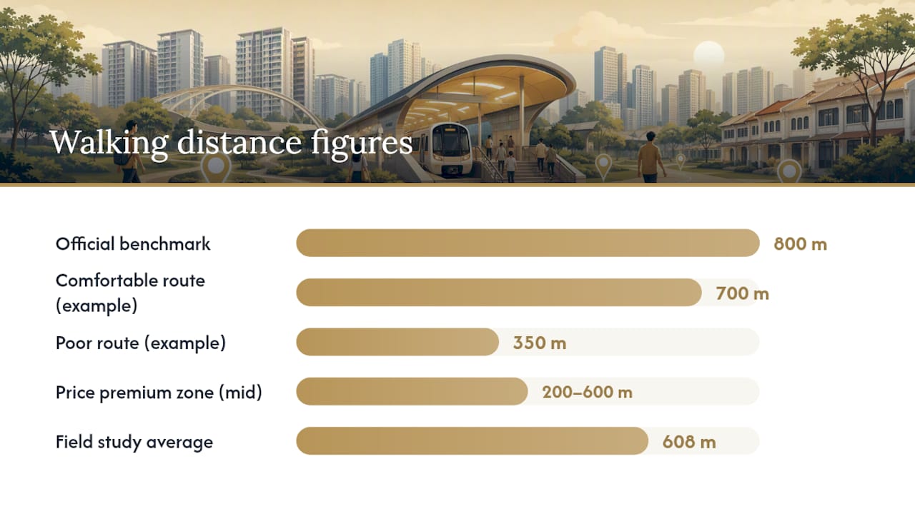
The 10-minute, 800-meter benchmark gets treated as gospel in property listings, and that's the first thing worth pushing back on. It's a useful ceiling, not a guarantee of comfort. A 700-meter walk with a sheltered, flat, direct path beats a 350-meter walk that zigzags around a construction site and dead-ends at an unsheltered crossing. Distance is the number everyone quotes because it's easy to state; route quality is the number that actually determines whether you'll walk it every day or give up and call a ride within the first month.
The property market has mostly caught up to this, which is why the price premium curve is steep between 200 and 600 meters rather than flat all the way to 800. But buyers still lean too hard on the marketing distance printed on a floor plan and too little on doing the walk themselves at 8 a.m. on a Tuesday. If there's one thing worth prioritizing before signing anything, it's this: verify the route with your own feet, not someone else's site plan. The 608-meter average from field studies exists precisely because real walking behavior rarely matches the straight line drawn on a brochure, and the properties that hold their value best over time tend to be the ones where the advertised distance and the lived distance are the same number.
— Velisa
Ready to see how walking distance and connectivity play out in an actual project? Explore Aurea's latest updates for details on its Beach Road location, unit layouts, and direct access to nearby MRT stations.
This article is general information, not a substitute for advice from a qualified financial advisor. Consult a qualified financial professional about your own circumstances before acting on anything here.
Sources
- In the Singapore context, how long should the walking distance be to be considered walking distance to an MRT station?
- Using Equivalent Walking Distance to Assess Pedestrian Accessibility to Transit Stations in Singapore
- Getting Around | SMRT
- How MRT Distance Affects Singapore Property | Winfred Quek